What is the Cornish Natural Resources Inventory? (2021 No. 1)

Home » Corey Fitch » Page 6

The Cornish Conservation Commission is pleased to introduce Cornish Conservation Notes in 2021. We will regularly highlight sections of the NRI, providing information about our collective natural resources and our efforts to protect and enhance them for all Cornish residents.

The Cornish Conservation Commission celebrates its 50th year anniversary in March! The purpose of a town Conservation Commission, as stated by NH Law (RSA 36-A), is to work toward “the proper utilization and protection of the natural resources and for the protection of watershed resources of said city or town.”

In the summer of 1975 the Commission hired intern William F. Menke to conduct its first audit of resources. The following year his work had been reviewed and the first NRI for Cornish was published. The document is a 46 page narrative of facts, figures and Cornish history, and it included 5 final pages of recommendations to the Commission. Menke encouraged a focus on creating town recreational opportunities, preserving cultural/historical areas, increasing the outdoor educational opportunities for the school, capitalizing on the CT River as a resource, and phasing out the Cornish Dump to protect the town aquifers. Since those first recommendations, it is satisfying to note that Cornish has acquired and developed the CREA property, purchased a parcel of land for a Town Forest and built trails, preserved buildings and land of historical value, rid itself of a dump, and much more.

The first NRI is a fun read, a tour of what Cornish looked and “felt” like in the summer of 1975 when Menke roamed the hills and vales of our town, and spoke with a great many townspeople. And it provided an excellent springboard for early guidance and actions by the Commission. And it eventually led to the next NRI, published in 2013, a much enhanced inventory, with new and growing information, and evolving recommendations to guide the Commission and Town.

Find these documents at the Cornish Town Library and town website and read for yourself about the unique character of Cornish, and the myriad forces that have shaped and continue to shape our town.

Read the 2013 NRI

Jody Schubert, Conservation Commission Member

Exploring the Biodiversity & Culture of the Connecticut River (2022 No. 7)

On July 9th, 15 boaters in 14 boats (kayaks and canoes) put in a Kilowatt Park in Wilder to paddle north on the Connecticut River as part of the 3rd in our summer series, Wild About Cornish, sponsored by the Cornish Conservation Commission. Joining us on that spectacular summer day were Kathy Urffer of the Connecticut River Conservancy (CRC), and Sandy Sonnichsen, a Fish and Wildlife biologist/volunteer for the Sullivan County Conservation District. Also an excellent overview of boating safety and group paddling instructions was provided by our kayak outfitter and instructor, Bonna Wieler of Bold Paths Adventures. To begin our water journey, Cindy Heath (CCC member and organizer of the day’s event) shared a Land Acknowledgement of First Peoples and also gave a short indigenous historical perspective of the CT River which was provided by Denise and Paul Pouliot of the Cowasuck Band of the Pennacook-Abenaki people.

Our original plan was to explore Chase Island located in Cornish, south of the Cornish-Windsor covered bridge, and home to the endangered Cobblestone Tiger Beetle, but low water conditions in the river on our scheduled date prevented appropriate access for a large and relatively novice group of boaters. Given that all were amenable to a change in plans on short notice, we traveled north instead to Kilowatt Park.

The 3-hour paddle was punctuated by a raft-up moment along the river to hear Sandy speak to river health, including fish and aquatic invertebrates so important to the aquatic food web, and also specifically about the Cobblestone Tiger Beetle, which only lives in the open habitat on the upstream end of free-flowing river islands and specifically in and around the pebble and cobble-sized stone areas. The upstream sections of Burnaps, Chase (in Cornish), Hart, Johnston, and Walpole Islands in the river all provide suitable habitat. The beetle does not tolerate heavy sedimentation or dense vegetation cover which often grows at the downstream edges of the same islands (and the reservoir-like area north of Wilder Dam is not a suitable environment). Chase and Walpole islands had the highest count of beetles in a 1993 study, and the beetles were still documented to be present in a 2014 survey. Landing boats on islands where beetles are present, and walking on the cobblestones have the potential to trample larvae in their burrows. All islands that support Cobblestone Tiger Beetles are protected under the state Endangered Species Act.

The Connecticut River was designated as an American Heritage River in 1999. The Silvio O. Conte National Wildlife Refuge Act (1991) and the Rivers Management Act (RSA 483) protect the river. The July 9th boating group landed on Gilman Island for lunch and River Steward Kathy Urffer, described the mission and focus of the CT River Conservancy.  CRC is a voice for the entire CT River watershed, from source to sea and collaborates with partners in all four New England states to protect and advocate for the river’s health and for education and recreational opportunities for all citizens who live along its shores. The CT River is the most extensively dammed river in the nation. Currently 5 hydro plants in the heart of the CT river watershed are renewing their operating licenses for the next 40-50 years, and include 3 in VT/NH: Wilder, Bellows Falls and Vernon. The two companies operating these dams designate only 0.6-.08% of their operating budget on existing recreational infrastructure. To learn more about CRC’s advocacy for river health and recreational benefits for the next 50 years, watch the attached YouTube video and or visit their website at ctriver.org. Information on how you can share your opinions, requests and dreams for the next generation of river users can be found on their website.

Cornish is fortunate to have a section of free-flowing river as its western township border. Whether you are a boater, painter, birder, fisherman or photographer, summer is the time to get out and enjoy the beauty and diversity of habitat it provides for all!

Effective Use of Culverts, Ponds and Other Water Control Measures (2022 No. 6)

An important aspect of conservation of water, soil, and habitat that is often overlooked are drainage control structures. If they work right, then they usually become essentially invisible.   When they don’t, incredible damage can result.

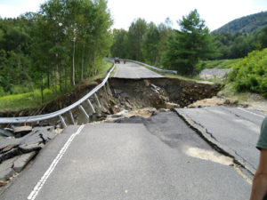
Floods or high flow events will always be with us.  But it’s our water control measures or drainage structures, that if properly designed, can mean the difference between just another beautiful day and disaster, with its accompanying potential loss of life.  The above is an extreme example, but not so much as you might think. In Cornish, high rain storms and snowmelt runoff this spring caused a few road closures and extensive repairs to put things right.

Culverts are not only designed to pass water flow under roads and driveways, but can provide a critical conveyance for wildlife habitat and fish passage. They need to be designed to minimize impacts to the natural channel wherever possible. Type, size strength requirements, location, pipe material and environmental issues are all important elements of culvert design. It’s certainly an engineering task to balance the many needs we place on these structures. In addition to the initial design and installation, maintenance is needed to keep them functional.   Given their importance, permits are required before installation to provide for proper review and evaluation.

In addition to culverts, ponds and dams also serve as important water control measures. In many instances, dams are used to create a pond or impoundment. Depending on the height of a dam or size of a pond, it would fall under jurisdiction of the State of NH and would require periodic inspections. The pond acts as a buffer to control water by delaying the time for water to pass and can act as an energy dissipator to reduce potential destructive energy in fast moving water flow. Many ponds and dams have a concrete outfall that directs the flow to the natural channel.

Effective use of culverts and other water control measures requires a technical understanding of hydraulic and fluid analysis as well soil mechanics to control erosion and sediment along with the management of water quality and pollutant loading. Given the importance of drainage as it applies to roads and bridges, The NH Bureau of Bridge Design and Bureau of Highway Design share the responsibility for design of drainage. The separation of responsibility is based upon the size of the structure involved.

The photo below was taken on a road during Hurricane Irene in 2011 that just a few minutes before had been structurally sound. A culvert became clogged and water ran over the road and undermined the entire road. The repairs and material required to open this road were extensive and the road was closed for more than a month. A great example of the power of water. Which underscores the importance of keeping water flowing where it belongs.

Currently, there is no official count in Cornish of all the installed culverts.  It’s safe to say that the number of culverts in Cornish measure at least in the hundreds and maybe as high as 1500.    On the dam side, according to the NH Dam Bureau, there are around 38 dams in Cornish.  Most are impoundments for individual ponds, or fire ponds.  Some of the more important dams in town include the Blow-Me Down Mill Pond near St Gaudens, the swimming hole on Leavitt Hill Road, and the Whitewater Reservoir.

#5 A New Understanding of Wetland Ecology

A New Understanding of Wetland Ecology (2022 No. 5)

In Cornish Conservation Notes 2021/# 8, (scroll down), we defined the different types of wetlands and described the rich plant and animal wildlife found in these special habitats. Wetlands are among the most biologically diverse, productive, and unique habitats on earth. No other part of our landscape provides so many benefits at so little cost to the public, including flood control, water quality maintenance, groundwater discharge and recharge, and they provide beautiful vistas and recreational benefits for all to appreciate.

NH is the fastest growing NE state; our population doubled from 1960-2000 and is expected to increase 8.8% by 2040.  This population growth and the desirability of New England real estate in a rapidly heating global climate, means that Cornish could expect to see increasing pressures on our landscape and our natural resources in the future.

The Cornish Conservation Commission is currently updating the town’s Natural Resources Inventory (NRI) https://www.cornishnh.net/?page_id=912, which supports  the town’s Master Plan, and informs the Planning and Zoning Boards. This work is important in assessing land use patterns, and providing focus and guidance to the Town on land conservation efforts to protect important natural resources of the town. Land trust groups and societies like the Society for Protection of New Hampshire Forests utilize this kind of inventorying and town planning to help them determine the level of assistance they can render landowners seeking to conserve property and the natural resources they contain.

A high-quality wetland is typically defined (by the New Hampshire Wildlife Action Plan) as being:

  • At least 1000 feet from houses, roads or recreational trails
  • Surrounded by intact vegetation
  • In remote areas where beaver dams don’t affect humans

If you have one of these habitats on your land, please celebrate the gem you have, and work to protect this very valuable resource for your future generations, your wildlife neighbors that depend on them, and for the broader Cornish community.

Historically, New Hampshire has lost fewer wetlands to development than many other states. As southern New Hampshire faces increasing development pressure, wetlands and their very important surrounding uplands are at risk. Loss of upland habitat, pollution, salt runoff from roads and destruction of or loss of beavers and their dams all have a detrimental effect on how effectively these sensitive landscapes can continue to perform their much-needed ecosystem functions for us all. And read more about NH Wildlife Action Plan at https://www.wildlife.state.nh.us/wildlife/wap.html or view the Marsh and Shrub Wetlands brochure at https://www.wildlife.state.nh.us/nongame/documents/habitat-marshes.pdf

The New Hampshire Department of Environmental Services’ (DES) Wetlands Bureau administers the state statute protecting New Hampshire wetlands from “despoliation, and unregulated alteration.” The statute specifically authorizes conservation commission participation in the regulatory permit process. Please contact the Conservation Commission, or NH DES for more information.